Most road books are made using the dot-arrow or ball arrow system. So is just about every 4×4 road book you can buy on this website. Reading a roadbook like that is much easier than it looks. Allow us to explain.
A dot-arrow (or ball arrow) roadbook
A roadbook describes the entire route based on situation sketches of all important points (intersections, special obstacles, dangerous situations…). A point like that is called a waypoint.
At each waypoint, you get a sketch of the situation.
These are the rules according to the dot-arrow principle:
- You read the sketch from the bottom up. This is often indicated by a dot or ball but not always.
- The arrow indicates the direction to go in.
The sketch is further completed with factual information such as:
- Distance from the previous waypoint (i.e. the previous sketch)
- Total distance
- Any additional explanations
How to read a 4×4 dot-arrow roadbook?
The image below makes the principle clear.
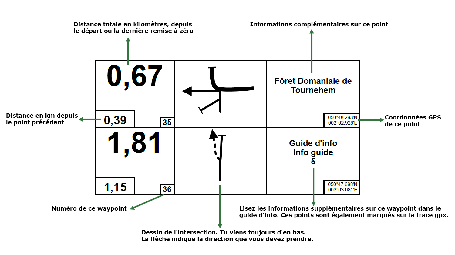
- Number 35 reads as follows: “After a total of 0.67 km (and 390 metres after the previous point), turn left. There is a Fôret Domaniale de Tournehem sign.”
- Number 36 means: “After a total of 1.81 km (and 1.15 km metres after the intersection of nu 35), you should turn left onto a dirt track. In the info guide you will find further information at point 5.”You see, it’s easier than you thought.
Please note: an app works better than your odometer
In most four-wheel drive cars, the odometer is anything but accurate. Deviations of up to 30% are no exception, especially if you have larger tyres. This makes it difficult to follow a roadbook correctly. And you’re pretty much guaranteed to turn onto a road too early or too late. Not much fun.
Download the app 3pMaster for iOS or Offroad Tripmeter 4×4 for Android if you want to avoid that. They give you a much more precise reading.
What else do I need to know to read a 4×4 road book?
- A solid line is a paved road.
- A dotted line is an unpaved road (dirt road, gravel road, grass road, …).
- At some points you’ll have to reset your counter to 0. This is indicated as follows:
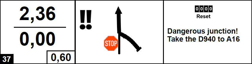
- If an intersection is not included in the roadbook, you should just continue to follow the main road.
- We take great care composing every roadbook. But roads, road signs and local traffic laws can change quickly.
Sometimes events can also make roads – temporarily – inaccessible. - That is why many roadbooks include the GPS coordinates at each waypoint. This way, if there are any interruptions or changes, you can easily rejoin the route further on.
Always respect the traffic rules. The publisher of the roadbook cannot be held liable in any way. For anything (fines, accidents, damage to vehicle, …).
And don’t forget: 4×4 driving is about enjoying spending time out in nature. Don’t turn it into a race. Always respect nature, local residents and other road users.